Version History
Here you can find the changelog of Hill Lists since it was posted on our website on 2016-10-01.
The latest version is 7.6 and it was updated on soft112.com on 01 April, 2024.
See below the changes in each version:
version 7.6
posted on 2023-09-27
Sep 27, 2023
Version 7.6
Updated to version 18 of the Database of British and Irish Hills (DoBIH), adding two new lists: the Ethels and Alan Dawson's High Hills of Britain.
version 7.5
posted on 2023-01-17
Jan 17, 2023
Version 7.5
Updated to version 17.5 of the Database of British and Irish Hills, with significant changes to the Grahams, Graham Tops and Highland Fives. See the user guide for details.
Added support for up to 3 user defined lists, where you can set the criteria (region, drop, height ... etc). Select Edit on the lists view and scroll to the bottom.
Re-enabled the multiple rounds setting. If disabled, only your first round of each list is tracked.
version 7.4.2
posted on 2022-07-28
Jul 28, 2022 Version 7.4.2
Updated to version 17.4 of the Database of British and Irish Hills, a routine update with minor changes to the Humps, Simms, Dodds, Nuttalls, Tumps, County Tops and Arderins.
version 7.4
posted on 2022-04-05
Apr 5, 2022 Version 7.4
When searching for a hill, include alternative names too.
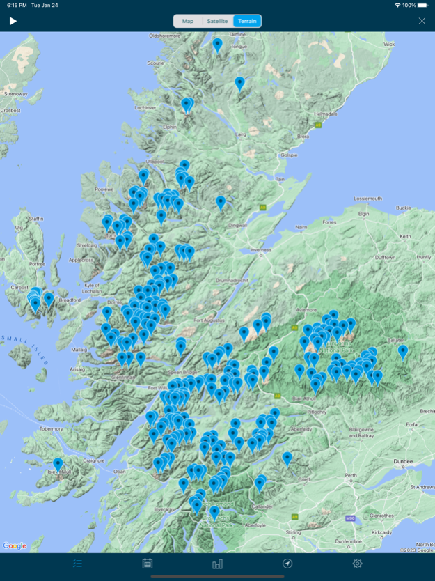
Added options to the unclimbed hills map accessed by swiping right to left on the lists view. For Munro Tops and deleted Munros, this includes showing the current Munros in grey (I find this useful when planning trips).
Added a top unclimbed hills section to the bottom of the dashboard view. This only includes hills in your tracked lists.
Added a fourth, darker colour theme, selected from the settings screen.
Minor layout improvements.
version 7.2
posted on 2021-08-14
Aug 14, 2021 Version 7.2
Moved to version 17.2 of the Database of British and Irish Hills (DoBIH), a routine update that reinstates Dugland to the Donald Tops, plus some minor changes to the Marilyns, Humps, Simms, Dodds, Donald Deweys, Tumps and SIBs.
Added regional lists for Scotland, Wales, England and Ireland.
For Scottish lists, the To Do section header shows separate counts for south and north of the Great Glen, plus the Islands.
version 7.1
posted on 2021-07-18
Jul 18, 2021 Version 7.1
Updated Google Maps behind the scenes. Some small visual changes like the map pins now have a small white border. Also added a compass to help align a rotated map. Still no sign of a scale control on Google Maps for iOS ...
Added animation support to most of the map views with climbed hills. Simply tap the play icon at the top left and choose a speed.
Added a distance calculation to work out the minimum distance you travelled between summits. Available when animating (above) and on the top year rows on the dashboard. My Munro round (e.g.) was at least 7016km or 4360 miles!
The app now requires iOS 11.0 or above (required by Google Maps).
version 7.0.1
posted on 2021-03-05
Mar 5, 2021 Version 7.0.1
Fixed a bug to do with importing Tumps.
When filtering on Landranger sheets, I now display the sheet number (iPad only).
version 7.0
posted on 2021-02-19
Feb 19, 2021 Version 7.0
Updated the underlying Database of British and Irish Hills (DoBIH) to version 17.1, a routine update with changes to the Marilyns, HuMPS, Simms, Dodds, Munro Tops, Nuttalls, Deweys, Donald Deweys, Highland Fives and County Tops.
Added support for the SIBs (Significant Islands of Britain), most are not easy to get to!
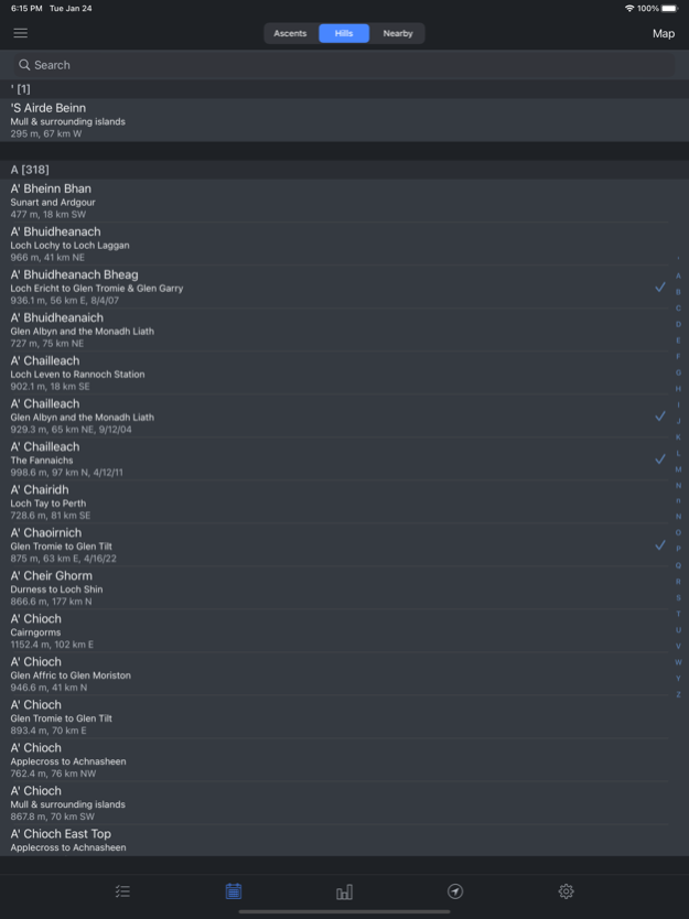
Added support for the Tumps (Thirty and Upward Metre Prominence). This is a huge list of over 17,000 hills. For performance reasons it is managed via a new Tumps filter on the location view (4th tab, top left). You can select and tick off hills from the map, and they will be included in the all ascents/hills view.
To help with ongoing lockdowns and staying local, added another filter to show all hills (including Tumps) on each of the Landranger 1:50k map sheets. This defaults to your local map sheet, but you can pan around the country to explore further afield. Enjoy!
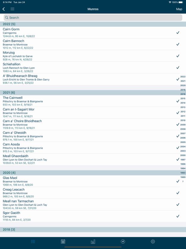
Ascents on an individual hill page are now shown in descending order, most recent first (as they are on the all ascents screen). For hills with lots of ascents (10 or more), added a quick index to scroll to specific years.
Performance improvements, especially when loading maps.
Backup improvements.
version 6.8
posted on 2020-10-13
Oct 13, 2020 Version 6.8
Updated the underlying Database of British and Irish Hills (DoBIH) to version 17. Minor changes to the Marilyns, HuMPS, Simms, Dodds, Nuttalls, Deweys, County Tops, Synges and Hewitts. Note the Munro Top Beinn a' Chroin West Top has been deleted, following confirmation by the SMC.
Also in version 17 the Dodds have been extended to Ireland, bringing them into alignment with the Marilyns, Humps and Simms. The list replaces the Myrddyn Deweys.
When searching for hills, I now match on ascent notes too. This lets you search for all hills climbed with a person, assuming they are mentioned in the log. Clearly if they are called Ben, you might get a few more matches than expected, perhaps use @Ben or #Ben in the logs!
When adding multiple hills on the same day, I now retain the order they were logged. This has always been the case with hills logged on the day, just not earlier days.
Bug fixes.
version 6.7.1
posted on 2020-09-17
Sep 17, 2020 Version 6.7.1
Added two new lists for their historical perspective: deleted Munro Tops and deleted Donald Tops.
Added a map view to show the location of an individual hill (when viewing any group of hills, or for each of your most climbed hills on the dashboard). Simply swipe right to left on a hill.
The location view now distinguishes unclimbed hills in your tracked lists (red) from other unclimbed hills (grey).
Added a map scale when using Apple maps (not yet supported on Google maps).
Added a new sort option showing year to date progress (vs the previous year). To make this more useable you can quickly re-sort your tracked lists by tapping the lists icon (bottom left) a second time.
Improvements to the underlying database, to reduce memory usage and speed a few things up.
Bug fixes.
version 6.7.1
posted on 2020-09-17
17 Sep 2020 Version 6.7.1
Added two new lists for their historical perspective: deleted Munro Tops and deleted Donald Tops.
Added a map view to show the location of an individual hill (when viewing any group of hills, or for each of your most climbed hills on the dashboard). Simply swipe right to left on a hill.
The location view now distinguishes unclimbed hills in your tracked lists (red) from other unclimbed hills (grey).
Added a map scale when using Apple maps (not yet supported on Google maps).
Added a new sort option showing year to date progress (vs the previous year). To make this more useable you can quickly re-sort your tracked lists by tapping the lists icon (bottom left) a second time.
Improvements to the underlying database, to reduce memory usage and speed a few things up.
Bug fixes.
version 6.7
posted on 2020-09-10
Sep 10, 2020 Version 6.7
Added two new lists for their historical perspective: deleted Munro Tops and deleted Donald Tops.
Added a map view to show the location of an individual hill (when viewing any group of hills, or for each of your most climbed hills on the dashboard). Simply swipe right to left on a hill.
The location view now distinguishes unclimbed hills in your tracked lists (red) from other unclimbed hills (grey).
Added a map scale when using Apple maps (not yet supported on Google maps).
Added a new sort option showing year to date progress (vs the previous year). To make this more useable you can quickly re-sort your tracked lists by tapping the lists icon (bottom left) a second time.
Improvements to the underlying database, to reduce memory usage and speed a few things up.
version 6.6
posted on 2020-06-18
Jun 18, 2020 Version 6.6
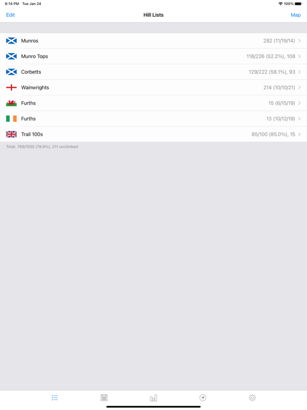
The lists view now shows completed lists separately, to make tracking multiple rounds easier.
The dashboard view now supports swipe actions, to show maps per month or year and to quickly add a new ascent of your most climbed hills. Simply swipe right to left on a month, year or hill.
Upgraded to the latest Dropbox framework.
version 6.5.1
posted on 2020-04-05
Apr 5, 2020 Version 6.5.1
Fixed an issue when importing ascents from a CSV file.
version 6.5
posted on 2020-02-28
Feb 28, 2020 Version 6.5
Updated to version 16.4 of the DoBIH (released on 26th February 2020). The Trail 100 list has been replaced by the new version published in February's Trail magazine. Other minor changes have been made to the HuMPs, Simms, Dodds and Fellrangers.
Added list completion dates to the lists view (displayed when complete, unless you have multiple rounds configured).
Added the hill's relative height (also known as drop or prominence) to each individual hill page.
Added an option to filter the location view map by height (3000ft, 2500ft or 2000ft), drop (150m or 100m) or to distinguish tracked lists. When viewing the map (4th tab), tap the location view icon a second time.
Added a setting to change the climbed hills colour to blue (for some people, green and red are not a good combination).
version 5.0.1
posted on 2009-05-25
version 6.6
posted on 1970-01-01
18 cze 2020 Version 6.6
The lists view now shows completed lists separately, to make tracking multiple rounds easier.
The dashboard view now supports swipe actions, to show maps per month or year and to quickly add a new ascent of your most climbed hills. Simply swipe right to left on a month, year or hill.
Upgraded to the latest Dropbox framework.